
Three Questions, Three Hazards, One Agent
What happens when a space agency, a cloud Earth-observation provider, and a global defense group each open PangeAI and just start typing.
We don't get to choose who walks through the door first. Someone opens PangeAI's geospatial agent, types a plain-language question, and finds out in real time whether an AI agent can actually reason about the physical world.
As part of the ESA Phinnovation Summit, we gave attendees hands on access to PangeAI's geospatial agents and three sessions stood out. . Not because the questions were exotic, but because of how ordinary they started, and how far they went. Here's what we saw.
01 - THE PATTERN
People don't ask for "geospatial analysis." They ask a question.
Nobody who has talked to PangeAI opened with "run a multi-temporal change detection pipeline." They opened with "show me this district," "what was the duration of the last flood," "can you show me data on this wildfire." That's the point. The barrier to Earth observation was never the data - Sentinel and Copernicus imagery is free and public. It was the five or six specialist steps between a question and an answer: defining an area of interest, picking the right dataset, handling projections, validating outputs. PangeAI is built to absorb those steps so the person asking never has to see them.
Three sessions show what that looks like when the person on the other end already knows exactly how demanding this work usually is.
02 - ESA: FROM "SHOW ME THIS DISTRICT" TO A FULL RESERVOIR INVENTORY
A single question turned into a four-step water-security workflow.
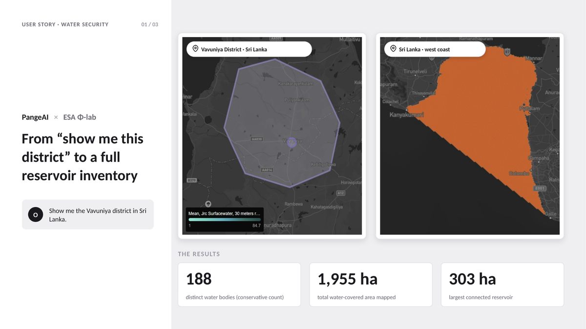
An Earth observation specialist at the European Space Agency opened with the simplest possible ask: "Show me the Vavuniya district in Sri Lanka." No brief, no shapefile, no coordinates.
From there, the conversation did what a skilled GIS analyst would do - except in minutes, in the same chat window. The area of interest moved to neighboring Mannar district. PangeAI identified the inland water bodies across it. Then, in the final step, it built a structured inventory of water reservoirs and irrigation tanks across the region - the same centuries-old tank network that still underpins agriculture in Sri Lanka's dry zone.
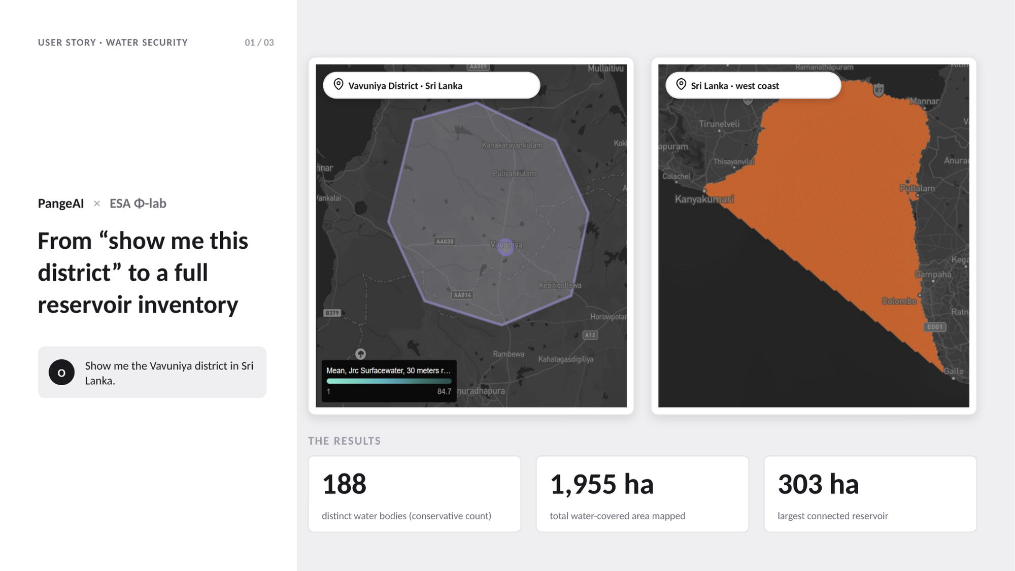
What started as "show me a place" ended as a decision-ready asset inventory: exactly the kind of output a water-security or land-monitoring program needs, produced without a single GIS specialist in the loop. That's the difference between a search engine for satellite imagery and an agent that can reason its way from curiosity to inventory.
03 - CLOUDFERRO: MAPPING A FLOOD WHILE IT WAS STILL NEWS
From "where do we even start" to a flood-impact map, in one working session.
CloudFerro, one of Europe's leading Earth observation cloud providers, is exactly the kind of organization that could build this internally - its own engineers work with satellite data every day. Its team came to PangeAI mid-scoping: defining the study area for a new geospatial project, then stress-testing the agent with a global risk-assessment question.
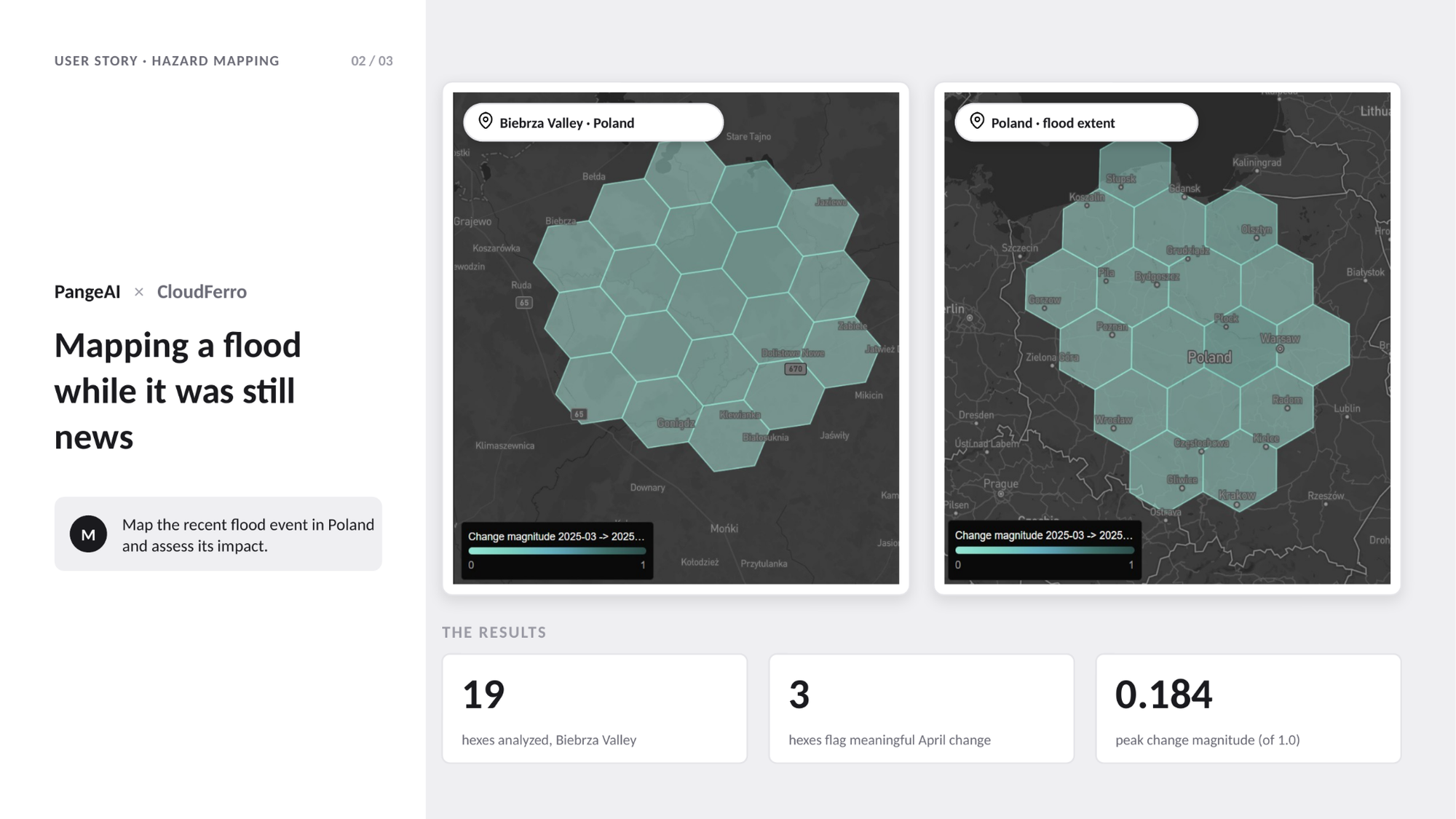
The real test came next: burn-scar detection and mapping over Poland's Biebrza Valley, followed by mapping and impact assessment of a recent flood event in Poland - the kind of task that normally means downloading rasters, calibrating imagery, and manually delineating extent.PangeAI returned a mapped, decision-ready view of the event instead.
When a company whose business is Earth observation infrastructure chooses to ask an agent instead of writing the pipeline themselves, that's a signal about where the value has shifted - from processing the imagery to reasoning over it.
04 - THALES: ONE AGENT, TWO HAZARDS, ZERO GIS TEAM
Wildfire in France, seismic risk in Japan - same interface, same afternoon.
A risk analyst at Thales Group asked PangeAI about a specific 2022 wildfire near Arcachon, France: "Can you show me data of it?" PangeAI mapped burn severity from satellite imagery on demand.
In a separate session, the same person asked a completely different question about a completely different hazard half a world away: seismic hazard and risk distribution mapping for Fukuoka, Japan.Three Questions, Three Hazards, One Agent
What happens when a space agency, a cloud Earth-observation provider, and a global defense group each open PangeAI and just start typing.
We don't get to choose who walks through the door first. Someone opens PangeAI's geospatial agent, types a plain-language question, and finds out in real time whether an AI agent can actually reason about the physical world.
As part of the ESA Phinnovation Summit, we gave attendees hands on access to PangeAI's geospatial agents and three sessions stood out. . Not because the questions were exotic, but because of how ordinary they started, and how far they went. Here's what we saw.
01 - THE PATTERN
People don't ask for "geospatial analysis." They ask a question.
Nobody who has talked to PangeAI opened with "run a multi-temporal change detection pipeline." They opened with "show me this district," "what was the duration of the last flood," "can you show me data on this wildfire." That's the point. The barrier to Earth observation was never the data - Sentinel and Copernicus imagery is free and public. It was the five or six specialist steps between a question and an answer: defining an area of interest, picking the right dataset, handling projections, validating outputs. PangeAI is built to absorb those steps so the person asking never has to see them.
Three sessions show what that looks like when the person on the other end already knows exactly how demanding this work usually is.
02 - ESA: FROM "SHOW ME THIS DISTRICT" TO A FULL RESERVOIR INVENTORY
A single question turned into a four-step water-security workflow.
An Earth observation specialist at the European Space Agency opened with the simplest possible ask: "Show me the Vavuniya district in Sri Lanka." No brief, no shapefile, no coordinates.
From there, the conversation did what a skilled GIS analyst would do - except in minutes, in the same chat window. The area of interest moved to neighboring Mannar district. PangeAI identified the inland water bodies across it. Then, in the final step, it built a structured inventory of water reservoirs and irrigation tanks across the region - the same centuries-old tank network that still underpins agriculture in Sri Lanka's dry zone.
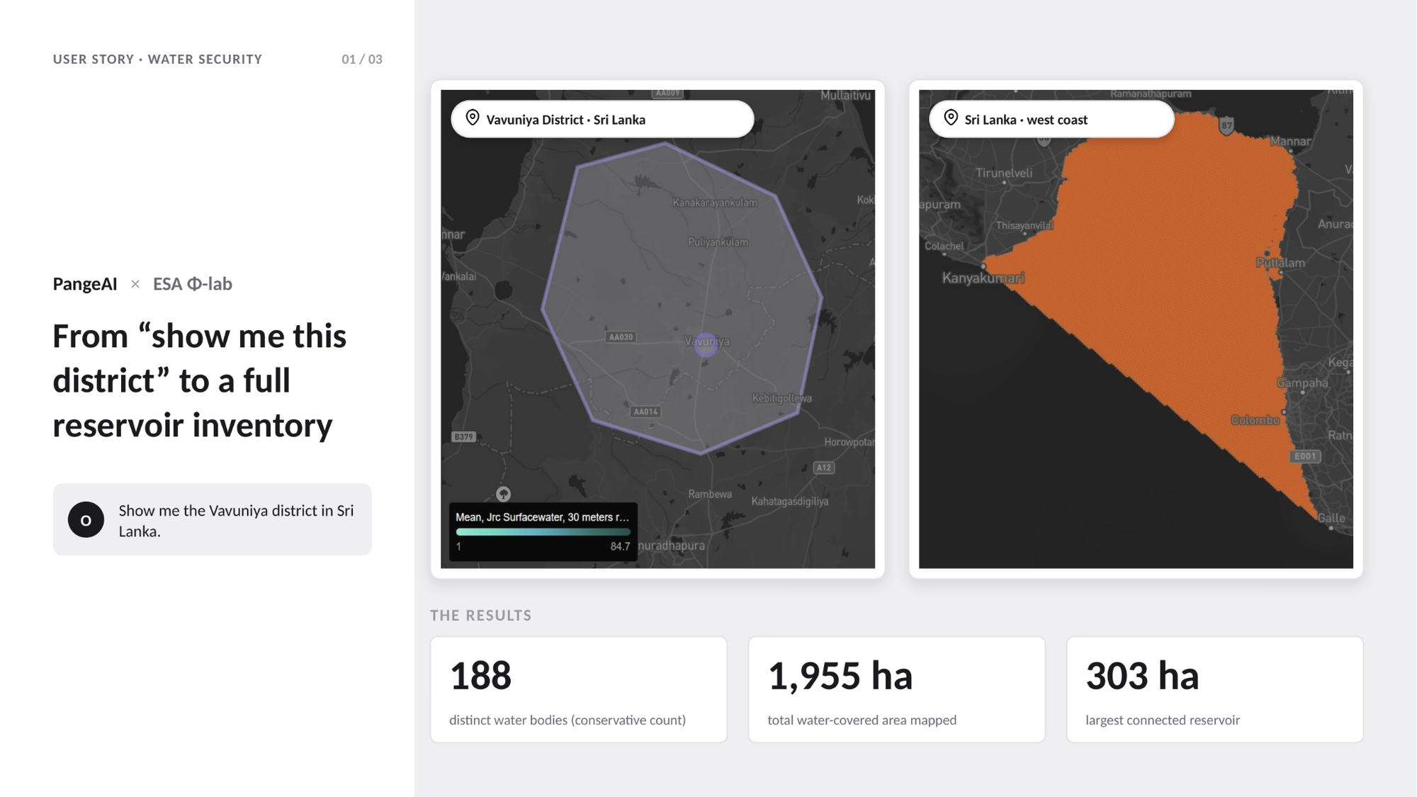
What started as "show me a place" ended as a decision-ready asset inventory: exactly the kind of output a water-security or land-monitoring program needs, produced without a single GIS specialist in the loop. That's the difference between a search engine for satellite imagery and an agent that can reason its way from curiosity to inventory.
03 - CLOUDFERRO: MAPPING A FLOOD WHILE IT WAS STILL NEWS
From "where do we even start" to a flood-impact map, in one working session.
CloudFerro, one of Europe's leading Earth observation cloud providers, is exactly the kind of organization that could build this internally - its own engineers work with satellite data every day. Its team came to PangeAI mid-scoping: defining the study area for a new geospatial project, then stress-testing the agent with a global risk-assessment question.
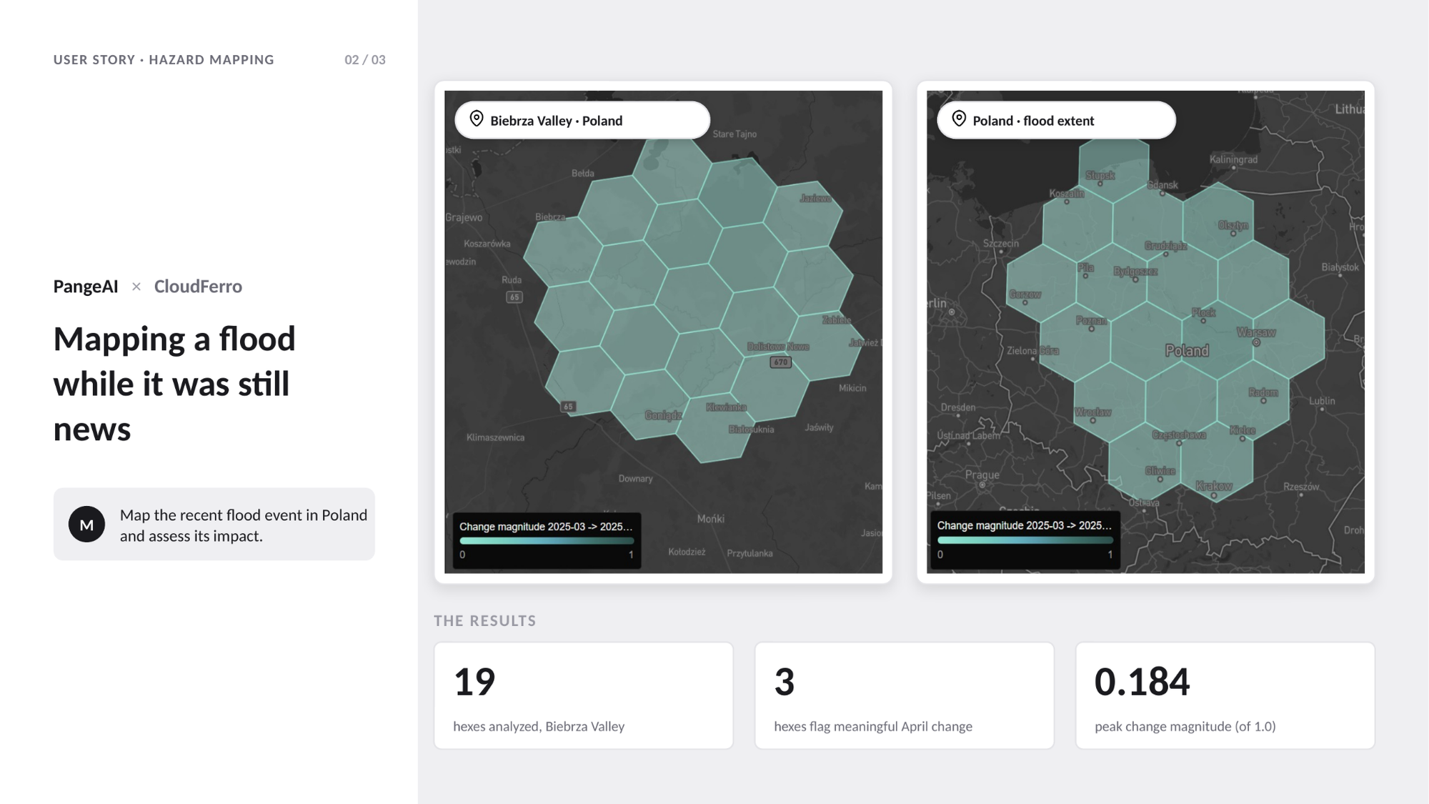
The real test came next: burn-scar detection and mapping over Poland's Biebrza Valley, followed by mapping and impact assessment of a recent flood event in Poland - the kind of task that normally means downloading rasters, calibrating imagery, and manually delineating extent.PangeAI returned a mapped, decision-ready view of the event instead.
When a company whose business is Earth observation infrastructure chooses to ask an agent instead of writing the pipeline themselves, that's a signal about where the value has shifted - from processing the imagery to reasoning over it.
04 - THALES: ONE AGENT, TWO HAZARDS, ZERO GIS TEAM
Wildfire in France, seismic risk in Japan - same interface, same afternoon.
A risk analyst at Thales Group asked PangeAI about a specific 2022 wildfire near Arcachon, France: "Can you show me data of it?" PangeAI mapped burn severity from satellite imagery on demand.
In a separate session, the same person asked a completely different question about a completely different hazard half a world away: seismic hazard and risk distribution mapping for Fukuoka, Japan.
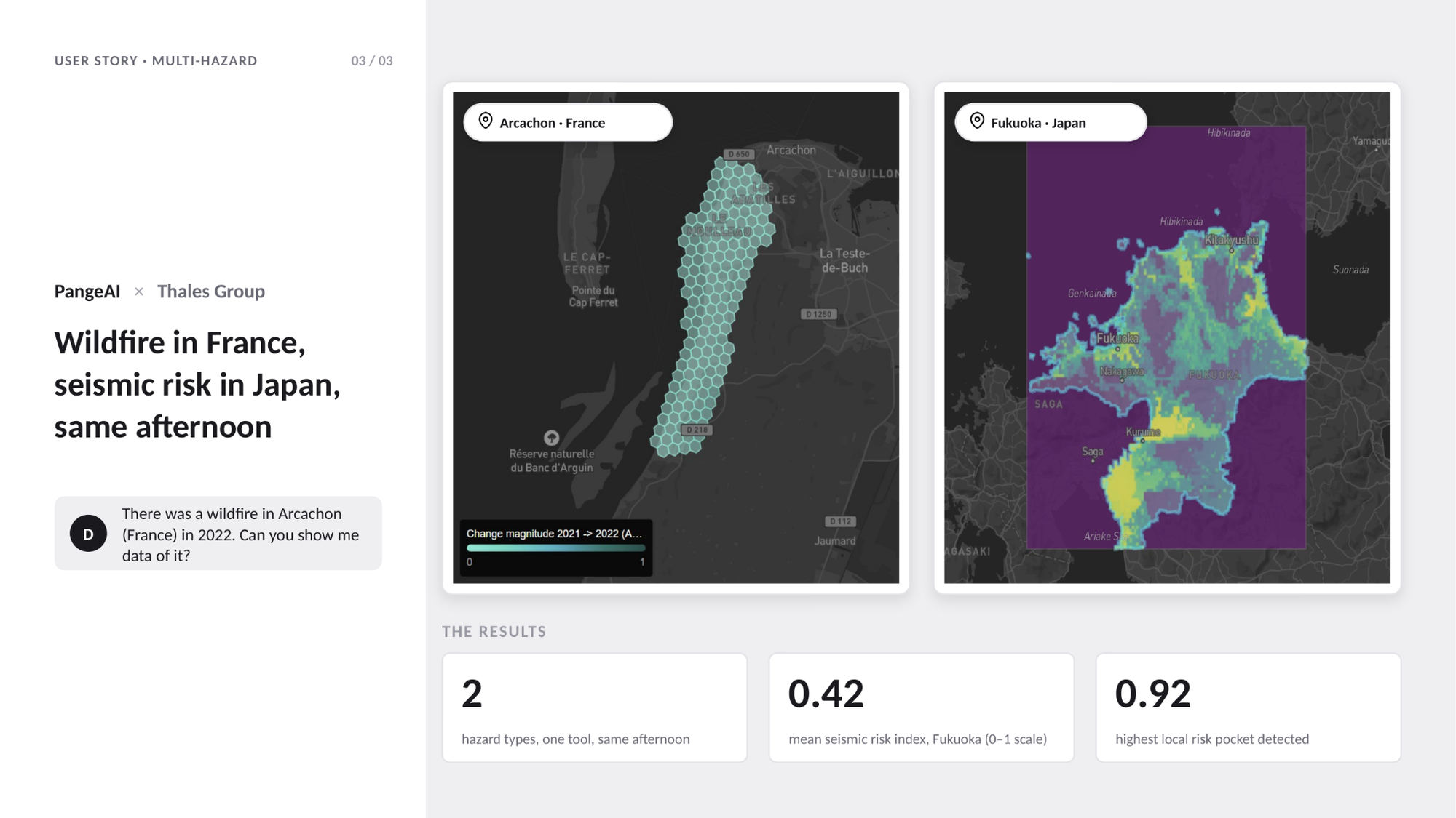
Two hazard types. Two continents. Zero pipeline switching. For an organization managing critical infrastructure and risk exposure globally, that's the actual product: one interface thatdoesn't care whether the question is fire, seismicity, or flood - because the reasoning layer sits above the data, not inside one narrow model built for one narrow hazard.
05 - WHY THIS MATTERS
The questions were ordinary. The organizations weren't.
None of these three questions were engineered as a demo. They were real people, at organizations that already understand Earth observation better than almost anyone, choosing to ask a plain-language question instead of opening their usual tools.
That's the bar we hold ourselves to: whether PangeAI holds up for the people who've spent their careers in geospatial data, and feels just as natural for the people who've never touched a GIS tool in their life.
Want to see what PangeAI can do with your own site, portfolio, or region of interest? Book a short demo.
Two hazard types. Two continents. Zero pipeline switching. For an organization managing critical infrastructure and risk exposure globally, that's the actual product: one interface thatdoesn't care whether the question is fire, seismicity, or flood - because the reasoning layer sits above the data, not inside one narrow model built for one narrow hazard.
05 - WHY THIS MATTERS
The questions were ordinary. The organizations weren't.
None of these three questions were engineered as a demo. They were real people, at organizations that already understand Earth observation better than almost anyone, choosing to ask a plain-language question instead of opening their usual tools.
That's the bar we hold ourselves to: whether PangeAI holds up for the people who've spent their careers in geospatial data, and feels just as natural for the people who've never touched a GIS tool in their life.
Want to see what PangeAI can do with your own site, portfolio, or region of interest? Book a short demo.